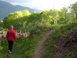
 The hills of northern Navarre have long since been domesticated with drystone walls and impenetrable thicket hedges, but the paths are still resisting. Unlike in England and Wales, they have never been tamed.
One evening, I tried to walk to nearby Zubieta, plainly visible in the valley below. I could see several paths and tracks heading in the right direction, and others which arrived successfully. But joining up the ends proved impossible. Likely-looking routes led to steep escarpments or trundled merrily as far as a barn and stopped. Of course there were no waymarks.
Chastened, the next day I took my GPS with me, only to discover that the tracks marked on the map were mostly fantasies. By dint of persistence I eventually found the way. It was only then that I realised that this is what Europe must have been like two centuries ago.* A typical meadow is dissected by three or four routes. And a little higher up, in the heath, there are tracks of all kinds running in every direction. Sheep, cattle, and humans are still maintaining paths and creating new ones.
In England and Wales it is a different story. Starting with the Industrial Revolution, as the countryside emptied into towns and tyres replaced feet, footpaths fell out of use. By the 1960s action was needed to preserve those which had survived. Definitive maps were drawn up. Since then, the Ordnance Survey and local councils have taken over. They are doing for paths what turnpikes and McAdam did for roads. Ways now have Rights. They are defined in law, regulated, mapped, and protected. There are fewer of them but they are better – they have been domesticated.
Of course, not all paths appear on OS maps, but walkers are attracted to those which do. Like electricity, walkers tend to pass where there is least resistance. Other possibilities are neglected and disappear.
Here, at the western end of the Pyrenees, the process of domestication has only just begun. In the rolling hills of the Basque country, lines of communication are still undisciplined and disorganised, but alive and kicking. Wild, in fact.
—-
Graham Robb’s excellent Discovery of France describes the phenomenon as it existed in 19th century France:
When Napoleon’s statisticians first surveyed the westernmost Breton département, Finistère, they were startled to find that almost one-fifth of the total surface was taken up by ‘roads and byways’… Further studies confirmed these incredible figures. Finistère was an extreme case, but many other départements turned out to be crazed with tiny roads. (pp 143–4)


Footprints on the mountains