

Cet article est également disponible en: French

Snowshoeing near Chioula, Aude
After my last disastrous outing, I’ve compiled a snowshoeing safety checklist for future use. My intention is to summarise the main issues involved, but this is not a definitive guide to snowshoeing and readers need to compare my thoughts with other sources.
As far as safety is concerned, snowshoeing is the equivalent of skiing. Many ski resorts now have dedicated paths for snowshoeing, which are perfectly safe. Anywhere off these paths and you are faced with the same issues as skiing off-piste. You either need to pay a guide (see list below) or to review the situation carefully.
Checklist for safe snowshoeing in the Pyrenees
- Planning
- Check out several alternative treks, so one can be selected on the day, according to weather and experience of group. Have a Plan B for when things go wrong.
- Calculate slope angle on and near route. Aim for less than 20° (37%) for greatest safety. Mature, dense forest also provides good protection from avalanches.
- Check out known avalanche zones online.
- Locate potentially dangerous snow bridges, over streams and in areas of karst.
- Is the path well used so that the snow will be trodden-down? If not, walking in fresh deep snow can take twice as long.
- If in doubt contact a professional guide or mountain rescue.
- Weather
- Follow the weather forecast for one week before the walk.
- The day before the walk, check out actual snowfall, wind and temperatures online and by telephoning your accommodation, nearest town hall (mairie in France, ayuntamiento in Spain, ajuntament in Catalonia and Andorra) or ski resort. Is the snow likely to be soft, hard, icy?
- On the day, take particular note of the weather trend.
- Wind speed and cloud cover are as important as temperature.
- Experience
- Check the experience of the group and adapt the snowshoeing to the weakest link.
- Only take people you know on difficult walks.
- Equipment
- I’m not going to consider avalanche beacons, shovels, probes, crampons and ice axes here. My philosophy with groups is to avoid areas where the slope angle is steep enough for avalanches to be possible.
Avalanche theory
Slope angle
None of the three stories told in my last article related to an avalanche, but it remains the principal danger for snowshoeing. So now, I only plan walks where avalanches are theoretically impossible. This means that we miss out on some of the more exciting summits that I might be prepared to do on my own, but it also means that everybody gets back home, and I don’t spend the weekend stressed out.
So where are avalanches theoretically impossible? On a wide, flat plain, evidently. Unfortunately, there are few areas in the Pyrenees that are both flat and high enough for snow but both Capcir and Cerdagne qualify. Even so, despite the relative security of flat plains, there is one significant danger: collapsing snow bridges. Although most snow bridges are over streams, near La Pierre-Saint-Martin the karst is full of treacherous holes.

Snow bridge in the Litor cirque (between Gourette and Arrens-Marsous). This picture was taken in summer but imagine yourself walking here a few weeks earlier when the snow was more extensive, and the soil and bracken completely hid the 4m drop.
Thick forest (mature trees spaced less than 3m apart) also provides pretty good protection as long as there isn’t a steep snow-laden slope just above.
Stick to the flat or the forest: that was the advice given on both the courses I took but I wanted more details. What exactly is flat? I asked. 10°, 20°, more? I couldn’t imagine an avalanche on a 10° slope. Nobody was willing to give a straight answer, but for the practical part of the courses we were taken out on 20° slopes.
So, since then I’ve tried to fill in the gaps, from the Internet.
- “Most avalanches start on slopes that are 30° or greater. If you stay off of 30° (and greater) slopes and avoid traveling beneath them, your risk is greatly minimized.” Outdoor Education Papers
- “Areas where the slope angle is less than 25° are generally safe, unless there is a threat from a large steep slope above.” New Zealand Avalanche advisory
The picture below is particularly telling
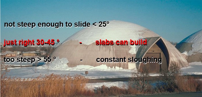
Under 25°, not steep enough to slide. 30–45° avalanche zone. Above 55° self-purging.
- The wonderful French government site GeoPortail considers 30° to be the point where slopes become dangerous
- According to Météo France, the French weather service: “The overwhelming majority of avalanches happen on slopes of between 25 and 45°”.
- There is a long discussion (in French) on Camp to Camp about minimum slopes. Most people see the lower limit as 25-30°. Only one of the writers, Alex, has seen an avalanche on a more gentle slope.
“In my opinion the slope was approximately 20°. It was the start of the season [early winter]. The base layer was very icy summer snow. Two 200mm-thick solid slabs, one on top of the other, slid for about 200m, finishing in a mess of blocks. The slabs measured about 100m x 100m and I would say that the speed was about 20km/hour, sufficient to churn them up, leaving a heap 800mm thick in the end.” - “When the snow is wet (from rain or thaw), liquid water melts the bonds and avalanches can occur on less-steep slopes, even on slopes less than 20 degrees. In the arctic, fast arriving springtime conditions may turn a snowpack to slush, and slush-flow avalanches have been observed releasing on slopes as shallow as 10 degrees.” Source.
- Another article suggests that only 1% of avalanches occur on slopes of 25-30°, with no figures given for less than 25°

Reviewing all this data it seems that the minimum possible avalanche slope is 20°. BUT there are two potential exceptions to this which need to be taken into acount:
- When there is a very compact and smooth layer of ice below a slab at the beginning of the season (see Alex’s eye-witness account, above).
- When the snow is saturated with water at the end of the season.
Bearing these two exceptions in mind, I consider that slopes of less than 20° are extremely unlikely to have avalanches. So, 20° has become my limit.
When looking at slope angle, I consider the following.
- Slope angle above route.
- Slope angle of route.
- Slope angle below route. An avalanche on a steep slope may pull snow with it from the ridge above it, where you are walking.
- Slope angle of hill on the other side of the valley. An avalanche may crash across the valley floor and climb up the opposite side.
Other angles to consider
- Nine fatal avalanches out of ten are caused by the weight of the walker(s) on the snow. If there is the slightest danger the group should walk 20m apart. Better: avoid avalanche zones.
- Type of snow (hard, soft, icy) and depth.
- Patches of ice may be hidden under thin snow.
- A cornice on a ridge may hide a steep slope.
- In cloud and in forest, navigation is particularly difficult; snow will have covered the path and waymarks. A GPS is essential.
- Snowshoeing uses much more energy than walking on the same terrain, up to twice as much. Maximum speed is about 2.5km/hour in good conditions.
- Walking poles with snow baskets (big discs which fit on the end of walking poles) are essential.
- Weather, particularly wind-chill
- Experience and equipment of the group.
- Tip: snowshoes are heavy – mine have a combined weight of 2.1kg. So, if the snow will support your weight without them, it is best to attach them to your rucksack. (A 1984 study by the U.S. Army Research Institute showed that extra weight on the feet is the equivalent of about five times that weight in the rucksack in terms of the effort needed for walking.)
21st century technology
Planning snowshoeing and off-piste skiing is now easy, using free software and maps available on the Internet. I suggest:
- Free GPS software Basecamp (0.1GB)
- Free TopoPirineos 8.0 map [Spanish ] (0.4GB)
I create routes on my computer and assess the slopes. There are also free online maps, but it is more work to assess slope angle.
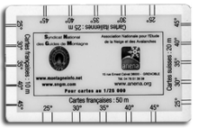
Slope ruler for 1:25000 maps
If you prefer to work with printed maps, you can buy a slope ruler for 1:25000 maps.

Measuring slope in the field. Now very easy with an app.
Practical example

Plan of walk (8.5km). North at top.
The Err-Puigmal ski resort has closed down but the road is kept clear as far as Cotzé. The slopes SW of Cotzé are relatively steep (25°) but are covered in forest, so slope angle isn’t an issue. Marked in red on the maps, the route has a maximum slope of 18° (see below).
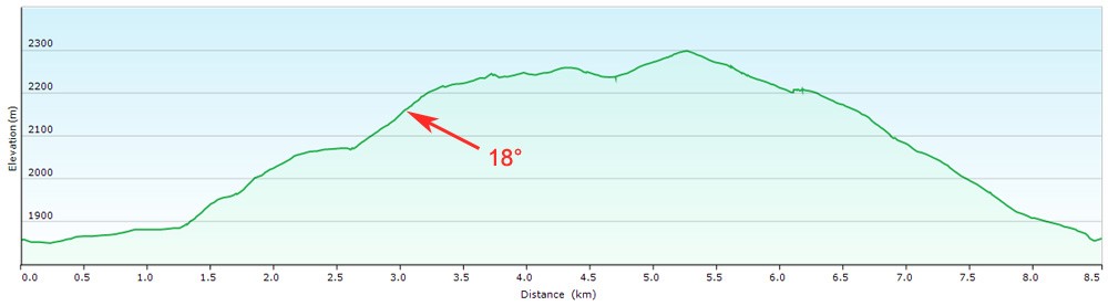
Profile of walk given by free Basecamp software
There was one zone to be avoided: the slopes on the SW side of the Serra de l’Artiga ridge (see below).
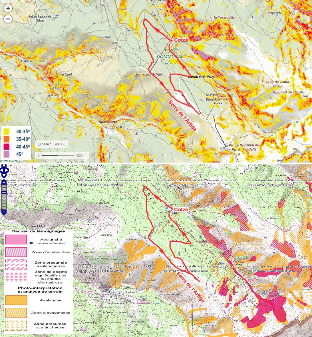
Avalanche zones near the Err-Puigmal ski resort. Above: Geoportail map based on slope angle >30°. Below: avalanches.fr map based on avalanche data
Useful information
Professional guides for snowshoeing in the Pyrenees
- Bureau des guides Ariège-Pyrénées
- Adventure Creators
- Bureau des guides de Luchon
- Bureau des guides de St-Lary-Soulan
- Bureau des guides de Luz-St-Sauveur
- Bureau des guides de Cauterets
- Caminando Cauterets
- Guías de Benasque (Spain)
This is not an exhaustive list. If your company works with professional guides diplômés d’Etat please let me know.
Mountain rescue
- Emergency telephone number: 112 (France, Andorra, Spain)
France
In France the Peloton de Gendarmerie de Haute Montagne (PGHM) organises mountain rescue and may give advice.
- Bagnères-de-Luchon, Haute-Garonne (31), 05 61 79 28 36, Facebook
- Oloron-Sainte-Marie, Pyrénées-Atlantiques (64) 05 59 10 02 50
- Pierrefitte-Nestalas, Hautes-Pyrénées (65) 05 62 92 71 82
- Savignac-les-Ormeaux, Ariège (09) 05 61 64 22 58, pghmariege@gmail.com, unofficial website
- Osséja, Pyrénées-Orientales (66) 04 68 04 51 03, Facebook
Spain
Mountain rescue in Spain is the responsibility of the Guardia Civil (police).
Andorra
In Andorra the Fire Service (Grupo de Rescate de Montaña del Cuerpo de Bomberos) organises mountain rescue.
Weather in the Pyrenees including avalanche risk assessments
- Météo France, montagne. This page also has data for the last seven days, especially useful in assessing the stability of the snow cover.
- Météo Ciel (France). Météo Ciel doesn’t have a forecast dedicated to the mountains so you need to select the nearest village and extrapolate (about 6°C less for every 1000m, windier the higher you get). The advantage is that rainfall estimates are given in millimetres.
- AEMet (Spain) forecasts.
- AEMet (Spain) recent weather data.
- Servei de Meteorologia (Andorra) with avalanche risk assessment.
- Catalonia avalanche risk bulletin.
Slope conversion: degrees to percent
| Slope in degrees | Slope in percent |
| 10° | 18% |
| 20° | 37% |
| 30° | 58% |
| 40° | 84% |
| 45° | 100% |
| 50° | 120% |
Avalanche zone maps: France
- France: Geoportail map showing slopes of more than 30°
- France: Avalanche zones near ski resorts, based on eye-witness reports and slope analysis
Note on French slope and avalanche maps
The Geoportail and avalanches.fr maps are very different (see example above)! They both show where avalanches are likely but use different source data. Geoportail shows all slopes of greater than 30°, where avalanches are likely. Unfortunately, 1% of avalanches occur on slopes of 25°–30° and these are not marked.
On the other hand, avalanches.fr shows those areas where avalanches have actually occurred (red) and areas where aerial photos and topographic analysis indicate they are likely (orange). The problem with this map is that only areas near ski resorts have been surveyed in any detail. There are no maps for the Canigó massif, for example.
Avalanche zone maps: Spain and Andorra
- Catalonia
- Val d’Aran
- Navarra
- Aragon, Aneto
- Andorra


[…] A serious situation Safe snowshoeing (2): techniques and technology […]