Details of a near-circular trek in the High Pyrenees (22-26 August 2011)
Notes
More info (photos and a description of the walk). All the refuges provide blankets but not sheets: bring your own sheet sleeping bag. At Estós and Portillon there is a charge for hot showers. Head torches are essential, as electricity is scarce and main lights are turned off early. Ear plugs are a good idea. Dormitories are mixed. Breakfast is usually early (no later than 8h00) so that the afternoon heat and storms can be avoided. The evening meal is at 19h00 or 19h30.
We left the car at the ski resort of Superbagnères de Luchon and took the ski lift down into town, then a taxi to the Hospice de France, our first overnight stop.
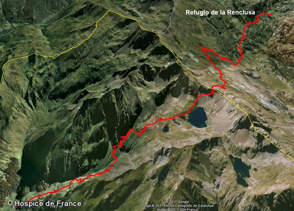
Hospice de France (near Bagnères de Luchon) (1388m) – Port de Bénasque (2444m) – la Besurta (1900m) – Refugio de la Renclusa (2140m)
Start time: 07h00 – Finish time: 14h30 – Total walking time: 6h – Not walking time: 1h30 – Ascent: 1296m – Descent: 544m – Distance: 13.5km
Navigation: Easy. Straight up the valley to the Port de Benasque (international frontier, but no passports needed), then follow the red-and-white GR waymarks down the other side. Cross the road and the pasture opposite and pick up the path which threads through the woods (or simply follow the road upstream). From the kiosk at la Besurta (drinks, snacks) follow a well-marked path across the river and up to the refuge.
Difficulties: After the Refuge de Benasque (food and drink available in July and August) the last few hundred metres are fairly steep. We had to cling onto the rocks because of the strong wind.
Accommodation: The Hospice de France has well above average facilities for a normal refuge price. There are bedrooms but we asked to be put in a dormitory because it was cheaper. We had two bunk beds and our own toilet, shower and washbasin en-suite. There was even a towel provided! The evening meal (soup, rabbit in mushroom sauce, local cheese, and bilberry cake) was prepared with care. The only thing which disappointed us was that Ingrid, the manager, was reluctant to cater for our early start time (leaving at dawn, 6h30), and didn’t want to leave us a thermos of coffee and a few crusts so we could serve ourselves without disturbing her. Eventually, we persuaded her to let us breakfast at 6h30 and we set out at 7h00, though normally breakfast is only served from 7h30 “when the croissants arrive from the valley, with the first bus”.
Access: Tarmac road access to parking just outside the Hospice de France. Busses twice a day (6€) and taxis (40€) from Bagnères de Luchon.
Refugio de la Renclusa (2140m) – Collado de Alba (3140m) – Pico Cordier (3254) – Collado de Alba (3140m) – Refugio de la Renclusa (2140m)
Start time: 06h00 – Finish time: 15h00 – Total walking time: 7h30 – Not walking time: 1h30 – Ascent: 1114 – Descent: 1114 – Distance: 10.1km
Navigation: Difficult in places. On the way up our local guide got lost, twice! Not seriously lost, but the return on the real path was much easier. Essentially, the track heads westwards from the refuge, following the south bank of a small brook, the baranco de Alba upstream, until the brook turns south-west. At this point the track crosses the river (cairns) and after 300m heads south to the pass (Collado de Alba). On the other side of the pass, it turns left passing behind the Pico Sayo, and sticks more-or-less to the same height until another pass is reached. It turns left again (E) and heads for the dip between the Pico Sayo (left) and the Pico Cordier (right). From the dip, the Pico Cordier is 250m SW.
Difficulties: At first – as long as the track is following the baranco de Alba westwards – this is classic mountain walking. But afterwards the route is merely a line of cairns across a lunar landscape, hopping and scrambling from one boulder to the next. The last 200m up to the Collada de Alba pass are very steep and the gravel and small rocks move dangerously. A light covering of snow would make this zone treacherous, so the walk is probably only practicable in August-September (or winter). From the pass to the summit it is back to boulder hopping: tiring but not particularly dangerous.
Accommodation: Refugio de la Renclusa (open all year). The young lad (possibly a trainee) who was looking after the reception was not at all welcoming or informative. The dormitories are quite big (30 bunk beds) but compartmentalised, which made them less noisy. Food was copious though the picnic sandwiches were poor (dry bread) and very expensive (12.80€ + VAT). One plus point is that breakfast is served from 5h00 onwards.
Access: On the Spanish side of the frontier, it is possible to drive to the car park just below the Hospital de Venasque and catch a bus to la Besurta (every 35 minutes, from 8h00 to 21h00 in summer). The refugio de la Renclusa is 40 minutes’ walk away from la Besurta.
Refugio de la Renclusa (2140m) – la Besurta (1900m) – Hospital de Benasque (1740m) – Baños de Benasque (1675m) – Rio Ésara (1535m) – Cabana de Literola (2020m) – Collada de Frontonet (2365m) – Cabana del Tormo (1740m) – Refugio de Estós (1890m)
Start time: 07h00 – Finish time: 17h30 – Total walking time: 9h00 – Not walking time: 1h30 – Ascent: 980m – Descent: 1230m -Distance: 21.7km
Navigation: Difficult in places. From the refuge down to the Hospital de Benasque (not a hospital, but a hotel) the path is well-marked (and even has maps designed for those who are more used to travelling in the Underground than walking on the mountains). At the Hospital follow the road E for 450m. Take the GR to the left (easy climb and descent) to the Baños de Benasque and then drop down to the river below, either on the winding road, or using the riverbed as a shortcut. On the other side of the river follow the road uphill to the main carriageway. Turn right and cross the bridge. 100m further on a well-defined track leads up the valley of the Literola to a shepherd’s hut, the Cabana de Literola (possibility of refilling bottles in river). It is here that the navigation becomes difficult. Cross the small stream to the south of the hut and turn left following the cairns, E at first, then S onto a plateau (2100m) where the cairns become scarce. Do not be tempted by the line of cairns heading SE. You need to follow a slight depression heading NW for 500m, without gaining much height (no obvious path). Then turn SW and head for the pass. From about 2200m the cairns reappear. Once at the col you will see a long grassy ridge heading SW down the other side. There is no path but it is easy walking. After 300m (2260m) join the path heading N for a short distance before heading E across the pasture. There are a multitude of sheep tracks and it doesn’t really matter which you take but try to pick up the path in the valley below somewhere after the Cabana de la Coma (we failed to do so). Aim to avoid the steep ravine of the baranco del Perdiguero, by crossing it at 1900m and no higher. Afterwards the path to the Cuartel de Estós and the refuge is well defined.
Difficulties: The only difficulty is the combination of distance and climbing which make for a long day.
Accommodation: Refugio de Estós. This is the most basic of the four refuges on the circuit. There are 115 beds (in big noisy, overheated dormitories) but only two showers, outside. The toilets and wash basins (cold water only) are 20m away. The picnic is the same price and quality as at the Renclusa.
Access: The easiest access is to follow the GR11 from the Benasque valley up the river Estós (2h).
Refugio de Estós (1890m) – Port d’Oô (2910m) – Refuge du Portillon (2560m)
Start time: 06h00 – Finish time: 13h30 – Total walking time: 6h30 – Not walking time: 1h00 – Ascent: 1020m – Descent: 350m – Distance: 8.3km
Navigation: Difficult in places. Mostly well-cairned but our local guide got lost again, taking us to the wrong end (E) of the Port d’Oô, necessitating a hands-on-rock detour to the W end.
Difficulties: The scree on the French side of the pass is steep and mobile, necessitating care (it would be easier to do in the other direction.) Once again a light covering of snow would make the pass unusable.
Accommodation: The Refuge du Portillon is modern and has a sufficient number of showers for the number of people. More to the point, the manager was welcoming and happy to cook me ham and eggs in the middle to the afternoon to keep me going until the evening meal.
Access: From Spain, using either the Port d’Oô or the Portillon d’Oô. Both are at the same altitude but the Portillon d’Oô necessitates crossing a glacier.
From France, a long but renowned walk from the Granges d’Astau (1137m) to the Lac d’Oô (1510m) and up the valley to the Lac du Portillon (2560m) (5h).
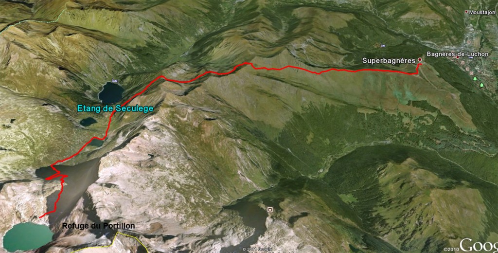
Refuge du Portillon (2560m) – Lac de Saussat (1925m) – Hourquette des Hounts-Secs (2260m) – Coume des Hounts-Secs (2140m) – Col (2270m) – Superbagnères de Luchon (1780m)
Start time: 06h45 – Finish time: 13:15 – Total walking time: 5h30 – Not walking time: 1h00 – Ascent: 465m – Descent: 1245m – Distance: 14.8km
Navigation: Easy, unless the fog comes down!
Difficulties: None.
Accommodation: In Bagnères de Luchon, in the valley below.
Access: Either by car on tarmac road, or by cable car from Bagnères de Luchon (July-August)
GPS track
Download .gpx track (right click) or .kmz (if you already have Google Earth installed clicking on the link should start it up.)
The GPS track here was recorded by Claude during our walk. However there are several points to note:
Sections not recorded
In a few places the GPS didn’t record properly so we have reconstructed our route (indicated by widely spaced track points)
1 From la Besurta to near the Hospital de Benasque.
2 After Hospital de Benasque to Baños de Benasque.
3 Along the GR10 after the final pass to Superbagnères.
Route wrong
The recorded route is wrong – we strayed from the path
- Between the Refugio de la Renclusa and the Pico Cordier we missed the path on three occasions. The return route, however, is correct.
- Above the Cabana de Lliterola, when we started heading west. Instead of struggling on the flank of the mountain we should have followed the much easier slight dip 80m to the N of where we were.
- Just before le Cuartal de Estós, we crossed the stream too high, scrambling through the woods. We should have lost more height before arriving at the stream.
- Curiously, the track misses the Refugio de Estós by 30m, though we did sleep there!
- We went to the E end of the Port d’Oô and then did a hands-on-rock traverse to get to the pass, at the W end. To be avoided.
- On leaving the refuge du Portillon we took the path heading NE, though my map shows a more direct path heading N.
Possible improvements
- The Aneto is a better target than the Pico Cordier and easier – except, perhaps, for short but vertiginous Pas de Mohammed.
- Instead of staying a second night at the Refugio de la Renclusa, it would have been better to continue down to la Besurta and catch the bus to the Hospital de Benasque, staying there overnight, making a shorter third day.
- We threw away much of the (dry) picnics, despite hunger. Two picnics between three people would do.
Thanks to Claude, Anne-Marie and Evelyne for company and photos.


Footprints on the mountains