Cet article est également disponible en: French
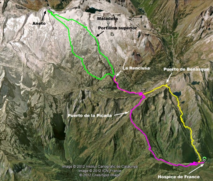
[Day 1: purple – Day 2: green – Day 3 yellow]
We are going to climb the Aneto, the highest mountain in the Pyrenees (3404m), but there are a couple of things we want to see before we put our boots on.
Our first stop is in Bagnères de Luchon, at the shrine devoted to Pierre Barrau. Barrau was one of the first guides to attempt the glaciers surrounding the Aneto; his untimely death was to put its conquest back by 20 years. Subsequently one of his legs became an object of veneration. It is not to be missed.
Barrau died in 1824. He had been engaged to take two clients up the nearby Maladeta, but he fell into a crevasse at the top of the glacier. For ten minutes he cried: “I’ve had it,” before disappearing. He was highly respected for his mountaineering skills and his death shocked locals. For generations they would point to the mountain saying “He’s there, poor Barrau.”
The miracle which led to his canonization and the construction of the shrine is that he continued to walk even after his death, heading slowly home. After 107 years he had progressed 1400m when walkers discovered him lying at the bottom edge of the glacier. He was brought back and buried, or at least most of him was. The leg bone appeared three years later. It now lies, finally at rest, along with one of his crampons in a glass case in the Luchon museum.
So that’s what happens when you fall into a crevasse…


Hi,
My name is Roger Kovary. I am a tour leader from the USA (www.climb-ecuador.com). I am organizing a group of about 10 people for a 17-day hiking trip to Spain. We’d like to finish our trip in the Pyrenees and climb Aneto and Pico Posets. We are all experienced mountaineers between ages 50 and 75. Would you be able to answer a few questions:
1) We plan to be in Benasque on June 4. Is this too early in the season to climb Aneto and Pico Posets? Will there be too much snow?
2) Would you be able to provide two guides for this four-day itinerary:
DAY 1: Benasque to Refugio de la Renclusa
DAY 2: Climb Aneto. Return to Benasque
DAY 3: Benasque to Refugio Angel Orus
DAY 4: Climb Pico Posets. Return to Benasque
3) What would you charge just for the guiding and group equipment? Would this include crampons or should we bring or rent our own? We can probably make our own reservations at Renclusa and Angel Orus.
4) We definitely need guides for Aneto, but have been thinking about climbing Pico Posets without guides. Is the climb of Pico Posets from Refugio Angel Orus, straightforward and easy enough to do without guides?
Thanks very much,
Roger Kovary
CLIMB ECUADOR
http://www.climb-ecuador.com
New York, NY
USA
Hi Roger
In theory you can climb both Aneto and Posets in June but it isn’t a good time of year. The snows will be melting. However, what you should do is contact the Guías de Benasque and ask their opinion – I am not a professional guide.
The guide will normally take care of the reservations and provide crampons, ice axes, ropes and harnesses. Given the conditions you are likely to encounter, I think you should have a guide for the two days because the final ridges on Aneto and Posets are very exposed and may well be icy. By the way, you would be better to catch the bus (check it is running that early) from the Besurta Carpark to Benasque; otherwise it makes a very long day (30km +1600m climbing).
Best wishes
Steve