

Map of the GR10 (Pyrenean Way) and GR11 (Senda Pirenaica) with accommodation
Cet article est également disponible en: French
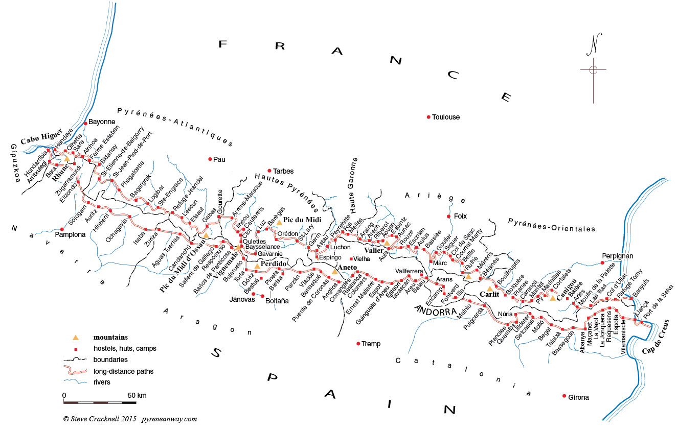
Huts, hostels and hotels on the GR11 Senda Pirenaica in Spain and on the GR10 Pyrenean Way in France (click to enlarge, see below for list)
This map is copyright © Steve Cracknell 2015, but you may use it on the following conditions
- It may only be used on a non-profit website and not in a printed publication. For other uses please contact me (high resolution vector version available).
- It must contain the copyright notice and must not be altered in any way
- There must be a link, either directly from the image or from the caption to this site: http://www.pyreneanway.com
Huts, hostels and hotels on the GR10 Pyrenean Way, in France
Most of the possibilities for shelter are marked on the map but please let me know if there is anything missing from the more complete list, below. Most of the hostels and huts on the GR10 are accessible by car. The others are shown in orange. From West to East:
- Hendaye
- Biriatou
- Olhette, recommended
- Sare
- Ainhoa
- Refuge de la Ferme Esteben
- Refuge de Bidarray
- St-Etienne-de-Baïgorry
- St-Jean-Pied-de-Port (meets St James’ Way here)
- Refuge de Phagalcette
- Refuge de Bagargrak (Chalets d’Iraty)
- Logibar
- Refuge de Ste-Engrace
- Refuge Jeandel (Arette-La-Pierre-St Martin)
- Refuge de Lescun
- Refuge d’Etsaut
- Gabas (note that the CAF refuge is definitively closed)
- Cabannes de Cézy (primitive hut)
- Refuge de Gourette
- Arrens-Marsous
- Refuge d’Ilhéou
- Cauterets
- Refuge du Clot
- Refuge des Oulettes de Gaube
- Refuge Baysselance
- Gavarnie (Refuge Grange de la Holle, recommended)
- Luz-St-Sauveur
- Barèges
- Orédon
- St-Lary
- Germ
- Refuge de Granges d’Astau
- Refuge d’Espingo
- Refuge du Portillon (above Espingo, off route)
- Bagnères de Luchon
- Artigue
- Cabane de Peyrehitte
- Fos
- Melles
- Refuge d’Araing, recommended
- Cabane d’Arech
- La Maison du Valier (gîte on the Ribérot river)
- Cabane d’Aouen
- Refuge d’Esbintz, recommended
- Refuge d’Aunac
- Refuge d’Aula (renovated in 2015)
- Refuge de Rouze
- Gîte d’étape l’Escolan, Bidous, recommended
- Aulus
- Refuge des étangs de Bassiès
- Refuge de Marc
- Refuge de Goulier
- Refuge communal de Siguer
- Col de Sasc (primitive hut, to be avoided)
- Cabane de Courtal Marty (supplies available)
- Clarans (supplies available)
- Plateau de Beille (ask Angaka for the possibilities ; the hut at 1940m is for the shepherd only)
- Refuge du Rulhe
- Auberge du Nabre, Mérens
- Refuge des Bésines
- Refuge des Bouillouses
- Bolquère
- Refuge de Planès
- Cabane de l’Orri (primitive)
- Refuge de la Carança
- Mantet (chez Cazenove, recommended)
- Refuge de Py
- Refuge de Mariailles (restricted access in summer)
- Chalet des Cortalets (accessible with 4×4 only)
- Batère
- Arles-sur-Tech
- Refuge du Moulin de la Palette is now closed
- Refuge de las Salinas hut (off GR10, on HRP, on Catalan side of the watershed)
- Refuge de Las Illas
- Refuge ‘Chez Paco’, le Perthus
- Refuge du Col d’Ullat, recommended
- Refuge Tomy, primitive but remarkable
- Banyuls
Huts, hostels and hotels on the GR11 Senda Pirenaica in Spain
Most of the possibilities for shelter are marked on the map but please let me know if there is anything missing from the more complete list, below. Most of the hostels and huts on the GR11 are accessible by car. The others are shown in orange. From West to East:
- Hondarribia
- Arritxulegi (primitive hut)
- Tellegi (bed and breakfast)
- Bera
- Zugarramurdi (off route)
- Elizondo
- Refugio de Sorogain
- Auritz
- Hiriberri
- Ochagavía
- Isaba
- Refugio de Zuriza
- La Cantina (primitive hut)
- Aguas Tuertas (primitive hut)
- Candanchú
- Formigal
- Sallent de Gállego
- Respomuso
- Refugio de Bachimaña
- Baños de Panticosa (Refugio de la Casa de Piedra)
- Refugio de Bujaruelo (recommended for its significance in Pyrenean history)
- Torla
- Refugio de Góriz
- Refugio de Bestué (off route)
- Bielsa (off route)
- Refugio de Pineta
- Parzan
- Refugio de Viadós
- Refugio de Estos
- Benasqué
- Puente de Coronas (hut)
- Anglios (hut)
- Refugio de Conangles
- Refugio de la Restanca
- Refugio de Colomers
- Refugio de Amitges (off route)
- Refugio Ernest Mallafré (lac de St Maurici)
- Espot
- Guinguetta d’Àneu
- Refugio de Estaon (recommended)
- Tavascan
- Àreu
- Refugio de Vallferrera
- Baiau (hut, recommended for the situation)
- Refugio de la Coma Pedrosa
- Arinsal
- Arans
- Encamp
- Refugio de Fontverd
- Refugio Estany de l’Illa
- Refugio de Engorgs (hut)
- Refugi de Malnui
- Puigcerdà
- Planoles
- Queralbs
- Refugio de Ulldeter
- Setcases
- Mollo
- Beget
- Talaixà (hut)
- Refugio de Bassegoda (key from café to east)
- Albanya (campsite with bungalows)
- Maçanet
- La Vajol
- La Jonquera
- Requesens (hut)
- Espolla
- Vilamaniscle
- Llançà
- Port de la Selva


Hi Steve,
I’d like to take my family of five (youngest 11) for about six days walking on the GR10 in the Pyrenees after which we will be heading (somehow) down to southern Spain .
What section might be good? I was wondering about around Canigou. Your favourite section around Cauterets also sounds great. I’d like somewhere reasonably easy to access cheaply and easily. We wouldn’t have a car. We would be staying in refuges (is it all right not to book far in advance even in summer holidays?).
Thank you. Hopefully this could be the start of a regular family mountain walking summer holiday!
Olly
Hi Olly
What is suitable depends to some extent on how much hill walking your kids have done, and how much they might enjoy, so please let me know: in some places refuges are 6-7 hours’ walking apart for adults. Yes it is alright to book in advance, but some won’t be taking bookings until they open in late Spring. Also do you have a time-slot for your holiday yet?
Steve
Hello Steve,
I want to ask by this way if the high resolution vector map version is still available, what a nice map.
I want to start the GR10 trail in June en walk until the end of July.
It would be helpful if I can have a copy of the vector map for my personal use.
Greeting, Willem
Hi Willem
I will send you a copy, bearing in mind that it is strictly for personal use. If you want to put it on the web or use it for a publication please come back to me.
Steve
Hi, wonderful and useful map! Can you recommend a couple of stages of the GR10 that will be good to walk in mid April without the risk of heavy snow/impassible sections? I’m aware that best time to do the route is June-September because of snow, but I’m wondering if there are some sections (perhaps not the highest mountain passes!) that can be walked in spring without getting a dump of snow!
My partner and I have a week or so set aside, we’re fit and experienced, and would love a challenge. We are currently living in a van, so a stage or two that is well connected by public transport (so we can get a bus and then walk back to the van/vice versa) would be excellent!
We have winter camping equipment, but would love to stay in some refuges if there are any open this tome of year.
Any suggestions greatly appreciated.
Hi Flyn
It is snowing at present all over the Pyrenees and there is more due this week. This will add to an exceptionally harsh winter – there is still a metre of snow on many ski resorts. So you will be limited to the two ends of the walk. However it won’t be a challenge for you! In a week you could expect to walk from Hendaye to St-Jean-Pied-de-Port, both of which have train stations; or in three days from Banyuls to Arles-sur-Tech, at the other end, from where you can get a bus back to the coast. You will find more accommodation open at the Hendaye end, so I recommend that.
Keep warm
Steve
Hi
I am looking to organise a small group of ex soldiers to walk the freedom trail, travelling light (25-35l daysacks only)
I am looking for any detailed maps but can’t seem to find any
(That’s not a good start nor does it inspire confidence eh?) LOL
Anyway I would appreciate any help you can give/email
Many Thanks
Carl
Hello Carl
You can find info on free downloadable maps of the Pyrenees here
Best wishes
Hello Steve,
What are the conditions to hike the first section of the gr-10 (Hendaye- St-Jean-Pied-de-Port ) in early May (next week), from 5th to May 12th 2018?
Is there still snow in this section, or are the conditions so bad that it won’t be fun?
Based on your answer on “08/04/2018 at 6:38 pm”, it seems this part of the section is possible.
Thanks a lot for sharing your experience.
Hi Lucas
Looking at the latest weather forecast for SJPP there should be quite a lot of rain before you arrive but should be fine and sunny, in low twenties C, from 6 May. I would be very surprised if you have any problems with snow on that section. (Please post report when you get back)
Have a great time.
Steve
Hi Steve
I have enjoyed reading all your information on here! Wow! We are heading to the Pyrenees-Orientales with 2 x11 year old pretty good walkers and a small dog. We will go in from near Toulouse ….We are planning on staying at refugi Rulhe for 2 nights and then have 3 or 4 nights before Descending to the coast at near collioure in France. We would love to walk from refuge to refuge or hear any other ideas you might have from all your knowledge of the area. I am a bit concerned about lack of shade so possibly keen to go lower rather than higher and be by water for fun swimming. I would really appreciate your advice!
All very best
Hi Flora
I’m assuming you must be going in school holidays then. And that you have a car. I wouldn’t recommend trying to do hostel-to-hostel as it could be tiring for kids. The Moulin de la Palette hostel has its own river and should be good for them. Or in Mantet try the Ferme Cazanove. Or the Chalet de l’Albère. Ask about Manel the shepherd, and go and see the ice house.
All have good food and friendly atmosphere.
Have fun. Collioure is great too.
Steve
Hello Steve,
Thanks for your reply about snow in May, we felt relieved with your reply!
After the trip, I can imagine snow will hardly be a problem to pass any part of this section in may. Unfortunately it rained a lot, especially in the highest parts (2 days Ainhoa-Bidarray-St Ettienne). In the Camino Frances day 1 traverse SJPP-Roncesvalles, it rained a lot for at least 6 hours, it even snowed, but after 5 hours in the rain the snow was a minor annoyance 🙂 Many times during the week we walked inside the rain clouds.
I would like to share our experience regarding accommodation: in most villages we stayed in B&Bs/pensions/airbnb which we reserved 1-2 weeks in advance. Almost all gite’s were fully booked 2 week in advance. From my experience I recommend to reserve gite’s well in advance.
Thanks for the nice website and all the information
Lucas
Hi Lucas
Thanks for the report. It’s a pity you didn’t see more; being in the clouds isn’t fun! Useful to know about your booking problems even so early in the season.
Are you thinking of coming back later?
Steve
Hi,
I’m planning on hiking the section from Espot – Torla-Ordesa this Summer as part of a trip to Spain, I estimate that it will take about two weeks. I plan on camping for most of the way, with a combo of camping food and food from accommodation. My main query is about places to camp, will there be places to set up camp or can I just camp in any reasonable place? And will I be able to use the toilets of places without actually staying there (important stuff)?
Hope you can help,
Kind Regards,
Tom
Hi Tom
There are a limited number of campsites and camping is not allowed in the Aigüestortes i Estany de Sant Maurici National Park. In the Ordesa National Park you can only camp near to the Góriz hostel and in Escuain (I think). Normally hostels etc don’t like you using their toilets unless you are using other facilities (buy a cup of coffee). However, there are plenty of other possibilities…
I guess you will be following the GR11 trek. If you are going before 14 July you may encounter snow.
It’s a great walk. Have fun.
Thank you Steve for advise given. We are all booked in to the Rulhe and Moulin de la Palette and Collioure, looking forward to it! One day we will be brave and stay in Refuge Tomy for a proper adventure!
All very best and many thanks again!
Flora
Hi Steve,
I did all the Pyrenées on my own when I was young in 1986. It didn’t fit completely the GR11, some route was on my own… Now I would like to visit some great mountains I missed with my daughter. Would you be so kind to send this vector map in high resolution that you have?
We want to climb the Anie and the Midi d’Osseau and find a hidden valley I met when I passed through…
Thank you very much!
Carles
Barcelona
Hello Carles
My map won’t be any use to you: it is vector but really only a sketch. You would be better to go to Wikiloc and search for HRP or GR11. There are lots of tracks that you can zoom in to.
Happy hunting
Steve
Hello Steve,
thank you for the info on your website. As a family we are off to stay in the Pyrenees very soon and I am keen to give them a taste of the mountains and huts. We are staying near Fos (the village is Aspet) and I wondered if you could recommend a few days trekking with one or two nights in a hut. Something that would give us a great taste of the mountains. We are all fit, strong walkers (my 12 year old son wants to be tested!)
Thanks in advance,
Julian
Hi Julian
There are several options not far from Fos. The easiest is to walk to the Peyrefitte hut on the GR10, then on to Luchon next day and get a taxi back. Beware, however, this is a primitive hut. Equally, this is not high mountains.
More interesting is to drive to the Granges d’Astau and walk up in the afternoon to Espingo then go on to the refuge du lac de Portillon the next day. There you will be able to see one of the few remaining glaciers of the Pyrenees. Say at Portillon and come back the following day. Equally from Espingo you could walk on the GR10 to Luchon
On the other hand you could drive to the Hospice to France and climb up to the refuge de Venasque and come back the same way the next day (having been up to the frontier to see Aneto oposite, the highest peak in the Pyrenees). If you aren’t too tired at the end of the first day make it a loop by coming back to the Hospice de France via the Pas de l’Escalette.
For the last two options you will need to book the refuges. For scenic value I would chose Venasque.
I hope this helps. Please let us know how it works out.
Hey Steve..
I’m going to the Pyrenees/GR10 in the middle of September to make a little research (walk 7-10 days) before walking the entire trail next year with some friends. Have decided to walk from Banyuls as I already have walked from St. Jean Pied de Port to Hendaye.
It would be great if you could send me the high resolution version.
Do you have phonenumbers etc to the hostels/albergues ?
We are planning to walk from the beginning of June 2019; do you think that it is possible thinking of possible snow on the trail ?
Thanks in advance
Per Damm
Hello Per Damm
Walking inland from Banyuls will be a bit of a repeat of walking at the other end of the mountains – not very high for the most part, and with plenty of hostels. Perhaps further inland would be more appropriate. Knowing your way across Ariège could be useful later on.
The map of the GR10 won’t help for walking, even at a higher resolution… Sorry but I don’t have phone numbers for hostels etc, though you will find them easily on the Internet.
As for starting at the beginning of June, if you had done that this year you would have run into problems after 2 weeks max. In a “normal” year your start would be OK but who knows how much snow we will have this winter. See snow reports for walkers in Spring 2019, as it gets updated.
Have a good trip.
Thank you for your earlier help. We are off on Friday and very excited. We have a GPS but struggling with maps/ understanding of how clear footpath will be. We are walking up to Refuge de Rulhe, along to Mérens les Vals, and then another 3 days staying at ecogite (as recommended) and walking along to Trabucayres.
I wonder if we are lucky enough to catch you at your computer and you could send the higher res maps I have seen you mention to others.
Thank you again for running this brilliant website, I have recommended it to many others who have been inspired by our trip.
All very best
Flora
Hi Flora
The high-res version of the map above is no use for walking. But don’t worry about the route up to the Rulhe refuge and along to Mérens. I recommend going to the Rulhe hostel via the Cabane de Rieutort to avoid the crowds. Though less well marked than the route via the cabane de Garsan, as long as you keep to the west side of the valley once you are out in the open you should be able to see the pass ahead of you.
After the Rulhe, the GR10 is now well marked, even where it crosses the boulders. Be careful however descending from the Crête de la Lhase. Some walkers have gone straight on at the first bend 200m after you pass over to the other side. You need to turn left.
I suggest you plan to set out real early from the Rulhe refuge. It will be a long day, best done in the cool of the morning.
Looks like the weather should be fine this weekend.
Have fun
Hello Steve,
I have eagerly devoured the content of your website – but am still a bit at a loss: I want to find a good 3-5 day route for earl October, ideally with proper “dramatic” mountain landscape. However, I’m on my own, i.e. it should be a route that is well signed. I’m coming from Bilbao and have hoped to be able to do the trip without a car – if at all possible. This trip of yours sounded great – but might be difficult without guide and car? http://www.pyreneanway.com/2011/09/circular-trek-in-the-high-pyrenees-5-days-on-the-edge/?lang=en
Do you have any recommendations? Thanks so much for your help!
Best wishes,
Nina
Hi Nina
You may still be OK for high routes in early October but beware of fresh snow. In any case for the Aneto/Maladeta range you need crampons and an ice axe. Also the route we took is not well signposted (we had a guide for two days).
On the other hand, the Senda de Camille could be a better option, both in terms of access and safety. Start/finish at Somport (near Canfranc railway station). Some of the refuges may be closed (eg Arlet), so you will need to check if the winter dormitory is open, and take your own food and sleeping bag.
I hope this helps.
Hi Steve,
thanks so much for your reply and suggestions (and for directing me to the right page…. – hopefully I will show better finding skills on the paths).
Sorry to add yet another question but I seem to get stuck with my research on public transport from Bilbao towards the Pyrenees. Do I just look at the wrong pages (not speaking any spanish the choice ist limited) or would I need a car after all?
Thankg again!
Best wishes, Nina
Blimey, this is getting embarrasing. You mentioned a train station… So please ignore my latest email.
Hi Steve.
Great website. Enjoy your twitter posts.
I’m walking from St Lary to Hendaye beginning on the 22nd September. Could I get away without taking crampons ice axe etc? Your opinion would be great. Also if its possible could you email me a high resolution version of the map.
Will
Hi Will
You won’t need crampons or an ice axe. A high-res version of the map is useless for the purposes of walking. It is just a sketch!
Have fun.
Hello Trail Friend!
We are planning a 2 day loop from Tavascan up to Certascan, staying overnight on October 5. It looks like we might experience flurries, or rain, or clear skies, and 30’s-50’s F at elevation. What website has the best mountain weather as we get closer to the date?
Many Thanks,
Bunnie and Allen from Atlanta, GA (and CA, AK, NH, etc)
Hello Bunnie and Allen
I was there (staying at Bordes de Graus, which is now shut for the winter) a couple of weeks ago. My guess is that you will be going up that way, through Noare. It’s a beautiful circuit, varied. I’m particualarly keen on the Romedo de Dalt lake east of the Certascan hostel.
As for the weather I use the Spanish service AeMet. There are two ways of approaching it, either by the nearest town in this case Lladore, for the valleys. Or by massif: Pirineo Catalán (Catalan Pyrenees). The nearest peak on the list to where you are going is the Pica d’Estats.
The most important thing to know about the weather is that it tends to deteriorate after 16:00. This is when the thunderstorms start if there are going to be any. The sky can change from completely blue to stormy in two hours. This daily phenomenon is very noticeable in summer, less so as the autumn wears on.
You should get the autumn leaves around Tavascan… Enjoy
Hello Steve,
Compliments with the nice map and all information about the GR 10.
This summer we would like to walk part of this trail with a group of teenagers, 5 experienced hikeleaders and 15 young people aged 14 -18 any recommendations concerning accomodation, security and other things we should think of would be very helpful.
Thank you very much,best regards, Michiel Blumenthal
Hello Michiel
In terms of safety you need to avoid snow. You don’t say how long you are going to be walking, but the best window would be mid July to mid September. Try to avoid more than 6 hours walking a day, starting really early (on foot before 8:00) to avoid the afternoon thunderstorms. Take at least one day off a week… There are various other hints on my page French Pyrenees GR 10 trail: a walker’s guide. Let me know if you want any more info on a specific area.
Hi Steve,
My 18 year old son, and 2 friends, are planning a week’s walking in the Spanish Pyrenees (flying into Barcelona) first week of July 2019. At this stage they are planning to camp, but we’re trying to encourage them to also consider using refuges/hostels, because of changes in weather, and the promise of food at a hostel/in villages! Looking at the distances, and your comments about not being able to cover very long distances in a day due to the up/down nature of the walking, I guess in a week they’d be lucky to make it to Andorra??… and then catch a train/bus back to Barcelona for flight home. I’m sure they’ll be fine, but I would value some reassurance, especially as my son is not that ‘forthcoming’ with details of their plans! best wishes, Fiona
Hello Fiona
I understand your concern, but at that time of year and that age they can afford to make mistakes. They will get wet, cold and tired. They will probably be over-ambitious…
Since they are flying in to Barcelona they will probably be more interested in the GR11 than the GR10, so can look at my other site on the Spanish Pyrenees. In a week, if they are starting from the coast, they probably won’t get as far as Andorra: tents and all the associated equipment will slow them down hugely. It is always interesting to try walking for two days with all the kit you are intending to take on a long trek. You soon find that you can get rid of things. The Americans call it a shakedown walk.
Note that you don’t need tents and can stay in free (basic) huts most of the time, with careful planning, mixing them with stays in hostels.
I hope this helps.
Hi Steve,
we (my husband and 13-year old daughter and I) are planning a 3 or 4 day hike in the Pyrenees this summer. The plan is to take the Yellow train from Villefranche to Planès (leave the car in Villefranche and stay at the refuge at L’Orri de Planès) and “walk back”. At what point would you recommend leaving the GR10 and heading back to Villefranche? After Mantet or after Py? I read Thanks!
Hello Anne
It is an interesting plan. I’m assuming first night in Planèes, second at Ras de la Carança. After that your best plan is to walk on the GR10 through Mantet and on to Py (otherwise you will have to walk on the road which is parallel). By the time you get to Py you will be tired, so stay in the (basic) refuge there (you will need to organise your own food). Then continue on the GR10 the next day to the Col de Jou – Tour de Goa – puig de la Falguerosa and down to Vernet where you can get a bus back (or leave the car in Vernet and take the bus at the start). I see that there are alternative ways down from either Mantet or Py, but I don’t know them.
One other possibility if you have a head for heights is to walk the magnificent Gorge de la Carança. It looks spectacular but really is perfectly safe as long as you hold the handrail. And the monkey bridges are fun.
best of luck
Thank you for the speedy reply and the suggestions, Steve. I wasn’t aware we could walk from Ras de la Carança to Py in one day!
Also, we will be taking a tent (learning experience for our daughter). I read somewhere that tents are not allowed near Ras de la Carança. My husband and I have walked the GR 20 a couple of times and we have always pitched our tent near the refuges. Is is different on the GR 10? What do you suggest we do?
Thanks again!
Hi Anne, I’ve camped there and this French site on the GR10 suggests camping at the Ras de la Carança, so I think you will be able to camp there. Do consider buying something from the refuge though. Going from Mantet to Py adds +200m and -700m so would take 2h20 in my estimation.
Happy planning
Hi Steve. Thank you for a fabulous site that’s helped tremendously over the last few years. Next week I tackle Esbints to Mérens Les Vals. From Marc to Goulier is a long day of course. Have you any experience of the variant marked on the printed 1:25000 map that winds out of Marc north of the official route along an acqueduc, saving some hundreds of m of ascent and a couple of km walking? It looks likely to save half an hour on a long day but isn’t written about in any guide. Many thanks if you have any thoughts! Mark
Hi Mark
Unfortunately, I don’t know the path you are talking about – I guess it is the one that climbs NNE from Laujou to the Bois de Mourillon. I’ve looked at it on Google Earth and if you are optimistic you can just about make out a path. The only solution is to ask when you get there. Best ask when you get to Marc.
Bonne continuation
Hi Steve,
I found your website while searching for a detailed map of the GR11. The map at the top looks like a good stage planner, but is it enough detail to actually walk the route? I keep reading about high res svg version, does that have OS style map detail? Or is none of this needed because it is all GR sign posted etc…. I have a GPS route that works in the Galileo app.
Also, I am looking to walk coast to coast starting very late August, early September, would you say that was a good time to go, and which direction would you recommend? At that time of year, would I need to book ahead hostels, or just take a lightweight tent?
How would you compare the GR11 to the GR10?
Thanks for you website, some good information.
Dave
Hi Dave
No the vector map isn’t good enough but you can use my GR11 track on Wikiloc, where you will find many others for comparison. The waymarks are not adequate on their own.
Late August is late to start. You may get snow from 15 October, so it depends on how fast you walk. In any case, in October the temperature will descend to around 0C at night. So go earlier if you can, say starting 15 August. (It has to be said that September is the best walking month; it’s just a pity you can’t walk the whole route in 30 days.)
I only recommend booking a couple of days ahead because if you are tired or there is bad weather your schedule will kill you. Though if you start 15 August you may need to book 3-4 days ahead until the start of September when things calm down dramatically. After 30 September many of the hostels will shut, leaving only winter rooms available. Walk west to east to get the best of the weather.
I never recommend taking a tent, but that is because I can’t stand the weight. As long as you can afford staffed hostels or are prepared to stay in free huts you can always find a roof every night.
As for comparing the GR10 and GR11 see this link.
Happy planning
Dave says: Thanks for your quick reply. I spotted your other page comparing the GR10 and GR11 after I posted, I’m taking in all advice about tents, weather, etc but I wasn’t aware it took so many days I am not able to start until about 28th August. So, what about the idea of walking west to east, missing the very central haut Pyrenees section and then rejoining to finish it off? If that was a workable option (i.e. suitable transport options) in your opinion, where would be good leave and then rejoin? Cabo to ? and then ? to Cap de Crues, or is this just a bad idea?
Hi Dave
I like mountains and the most dramatic part of the Pyrenees is in the middle. So that would be my choice. But in any case the access points would allow you do do either the middle half or the two quarters at opposite ends
GR10: Gabas — Mérens-les-Vals
GR11: Candanchú — Puigcerdà
All accessible by rail (or in the case of Gabas, a bus pretending to be a train)
Hi Steve, I can see you’ve answered a question about the Little Yellow Train before but can I ask another? I’d like to walk along the GR10 as close as possible to Villefranche, get the train from Villefranche to Latour (to break up the journey a little) and then re-join the GR10 after that. Will this be possible?
Hi Alice
There is a path down to Vernet from the Cortalets refuge on Canigou (via the Porteilla de Dalt), and a path down from Mariailles (via Col de Jou and Tour de Goa)/ You would then need to take a bus or taxi to Villefranche. Or, much more exciting, continue to the Ras de la Carança refuge and walk down the Carança to Thues (see photo below).
Unfortunately La Tour de Carol is way south of the GR10. You would be best to catch a train from La Tour de Carol to Mérens-les-Vals to rejoin the GR10 there.
Happy planning.
Hi Steve,
we are thinking about hiking for around 10-12 days in the central pyrenees starting at 29 September. Possible route (not clear yet) starting at Gavarnie but then over to the GR11 towards the east. We are experienced hikers, but are not planning on carrying ice axes/crampons/tent/food for more than one day. Do you think that is still feasible? Many refugios on the Spanish side still seem to be open.
Thanks!
Hi Caro
Sounds like a good plan as long as the refuges are open. You won’t need crampons on the GR11 and at that time of year you would be better off staying in refuges or free huts. The temperatures will get down to around zero at night. Gavarnie to Bujaruelo used to be a classic crossing point, though now much neglected. See also my site on the Senda (Spanish GR11).
Hi Steve,
thanks for the quick reply! So you think Gavarnie – Refugio de Goriz in one day is okay? It is not mentioned as an access route on the refugio’s website.
I only just noticed, am I right that you suggest Gavarnie – Bujaruelo and then Bujaruelo – Goriz?
Hi Caro
Normally the route would be Gavarnie – refuge des Saradets – Goriz but Saradets is closed, so yes via Bujaruello. The alternative, via Héas, Barrosa hut to Parzan, which is wilder – but then you would miss the Ordesa.
Hi Steve
I am still going west to east starting last week of August.
Would you take a sleeping bag 11-15 degree rating weighing 0.6kg and rely on clothing layers if it gets cold or a 0-5 degree rating weighing 1.6kg
I also have a silk inner, as I read I will need this is an albergue if not camping.
Thanks
Hi Dave
0-5. It may snow in early October, though it shouldn’t last…
Hi Steve, I’m setting off from Etsaut heading towards Luz Saint Sauveur via Pombie on the 1st September. I’ll be carrying a tent. I’m carrying some food and plan to resupply but I’d like to check etiquette with regards the refuges just in case (food weighs a lot!).
Is it OK use the aire de bivouac that some have and just avail myself of the showers/loos & food? Also, how critical is it to book in advance and would a day suffice or would two be better?
Thanks in advance
Mox
Hi Mox
In september a day in advance should be OK, particularly as you will be staying in a tent. Normally, if you make it clear that you are eating a meal in the refuge they will be understanding, but may make a charge for showers – some make an extra charge, even for those who are staying overnight – heating water is expensive.
I hope this helps
Steve
Hi Steve,
First many thanks for your website. It is a treasure trove of ideas and information.
I have walked a few times in the Cauterets – Ordiz area on the French and Spanish sides. I am planning a two week trek this summer and would like a circular walk on the GR10/11. I know the route from Cauteret to Torla via Vignemale. Previously I’ve hiked Ordesa and recrossed via the Breche. However I would like to walk further east (or west!) in Spain before crossing back into France and heading back to Cauteret on the GR10. Would you recommend a loop to the west or east of Cauteret – Torla? And is there a good point for recrossing from Spain to France within a week’s walking? Any advice/ideas gratefully received!
Best wishes,
John
Hi John
There are lots of possibilities, the most obvious being listed on my page on cross-border treks in the Pyrenees. East of Torla you can go on the HRP from Parzan to Héas, in two days, staying overnight in the free but basic hut at Barrosa or among the ruins of the Barroude refuge, in a room which must have been a store. Four walls, a roof and a door.
Further east you can go from Viados to la Soula. Both of these are a bit hairy at times.
Still further east you have Benasqué to Hospice de Luchon via the Refuge de Venasque. This is relatively easy and staying at the refuge near the pass would be a real treat. You will need to book.
To the west you have the Senda de Camille, also a magnificent crossing between Lescun and Linza… There are many possibilities. Look at wikiloc.com to see possible routes
Hello! I am hiking the GR-10 this summer and still in the initial phases of planning. I want to go to Andorra, but I notice that the trail doesn’t go thorugh it. What’s the best option for spending a little time in Andorra? Is it reasonable to expect we could find a way down into the country from the trail to perhaps spend a rest day there? Thank you!
Hello Katy
If you want to go to Andorra, you need to programme several days, because Andorra is higher than the GR10 and there are few easy passes. One easy trek is the Refuge du Rulhe via the Etangs de Fontargeante to the Juclar refuge. You could get back to Rulhe via the Etang de l’Estagnol. This is more demanding. Alternatively you can dontinue on to the Etang de Couart and descend the Ruisseau du Morguillou to Mérens-les-Vals.
Or, further west you can go up the valley from Gesties and end up at the Refugi de Sorteny. Long by not technical. From there go east on the HRP to Juclar and pick one of the options above.
It is possible to go from the Refuge de l’Etang de Forcat to the Etang de Guouille and then to the Port de l’Albeille to Sorteny but the first part of this down to the Etang is not a path, more a scramble over large boulders.
By the way, the villages in Andorra are mostly over-developed or over-renovated. In my opinion they are not worth seeking out specially.
Happy planning.
Dear sir
We have 7 days on october 15 to october 22 this year
We wish to walk the best part of the GR10
What would you recommend?
(I bet it is not the first time you are asked this question…)
Hello Taty
One problem with that time of year is that many of the refuges will be closed. You will need to plan your trip accordingly – it will be too cold to camp (below zero at night sometimes). See my page on snow in the Pyrenees. So you may want to stick to one end or the other.
Another is that if you are on the GR10 you will be a long way away from your start point. See this page for circular walks.
Happy planning.
Hi Steve hope you’re still tracking questions notwithstanding the pandemic. Your site always valuable. We’ve done hendaye to merens in previous years. We’re experienced hikers and planning for a Sept start hoping to finish things off this year, if things get back on track. But we’ll need to take a break in Vernet for a few days after five days, and we’re keen to stay HRP rather than GR10 if we can. Any comment on whether our planned route for that section is practical?
Le Soula to pitch tent at Estany Lanoset
Estany Lanoset to Bouillouses (via Pic Carlit)
Bouillouses to pitch tent at ruins of cabane de l’orri Baix
Baix to Ref Ull de Ter
Ref Ull de Terr to Ref Mariailles
Also if we needed to, would a 4×4 taxi be an option to get from the refuge down to Vernet do you know?
Thanks and really appreciate your advice.
Hi Mark
Yes, I’m still here. All good, I last did this as you are suggesting in 2016 but staying in hostels. Estany Lanoset (great place to camp) to Bouillouses via the Carlit. Be warned that the access to the top is via a steep scree slope. Best avoided if wet, but you can always fall back on the GR10.
Orri Baix to Ulldeter is one of the most magnificent ridge walks. Again, to be avoided in bad weather, witness the 9 crosses at Noucreus. Alternative is to drop down to Nuria.
However, the road up to Mariailles is blocked by a barrier at the Col de Jou.
Hope it works out.
Thanks Steve – great of you to get back so quickly on my plans. I had heard that the road to Mariailles might be permanently closed. I presume it’s ok to plan on walking down as for as Col de Jeu and getting someone to pick us up by car there? I think we’ll need to be down in Vernet by mid morning. Final question – what’s your sense of how chilly it gets in the evenings at these heights in early September? Our previous trips on HRP/GR10 have always been in refuges but given the pandemic we’re looking to make a virtue of necessity and camp where we can – but I’m not sure if my three season kit and an extra fleece will be enough if it gets really cold! Thanks again and best wishes. Mark
Yes, you can walk down to the Col de Jou and be met there. In september there is a big temperature gradient. I was once at bouillouses on 1 October and it snowed. However, the beginning of September is the best time to walk in the Pyrenees. The regular thunderstorms of July and August have abated, and it is not too hot. It might get down to 0degC at 2000m occasionally but mostly will bottom out a little above zero.
An alternative you might like to consider to camping is the free huts. I’ve done the three Pyrenean routes and only spent one night in a tent. I also know of a few that are not on the site I can let you know about if you are considering that.
Thanks Steve. I guess you prefer staying in the cabins even when they’re very basic and you’ve carried a tent with you, protected from the cold and wind. It looks from the photos on the refuge website like the one on the north west edge of Lac Lanoux (du Sola) might be a good option for the first night out of Merens rather than pitching the tent at Lanoset. But the one at Orrie de Baix looks in ruins. Any others you think I should consider? Thanks again!
Hi Mark
I didn’t carry a tent, given the extra weight. But yes, I prefer shelter. I don’t know the hut at Lanoux/Solà. The other hut that might be a possibility is the Cabane de Rouzet, but the last time I was there it was occupied by the shepherd. However, I recommend the Maison des Ingenieurs du Lanoux at the south end of the lake, since you are intending to go over Carlit.
The last time I went past the Orry de Baix it was pretty basic, but the situation was great. You might like to consider staying in the Cal Pai gîte in Eyne.
Steve you suggest dropping down to Nuria if the weather’s bad on the ridge to Ulldeter. If that’s the case would you rejoin at Coll de la Marrana having stayed at refugi de coma de Vaca or is there a safe way to get back into the ridge earlier? I guess the alternative if we don’t have an extra day is to drop back on the french side via Jasse de la Valleta and Etang de Caranca? Thanks again!
Mark, you probably won’t get as far as Coma de Vaca. Consider staying in the youth hostel or the hotel in Nuria. (Whatever you do, don’t eat supper in the youth hostel.) Then you can either go to the Coma de Vaca and on to Marrana. Or up the Torrent de Noufonts back to the ridge (for the ridge walk). Or miss the ridge walk out completely and go directly to the Col de Noucreus.
If you’ve got as far as the ridge there’s no great advantage in dropping down to the Carança – in any case you’d be better to do it via the étang Bleu.
One small thing I’ve found that may be helpful to others Steve is that the cabane at l’Orry de Baix has been rebuilt a couple of years ago. The comment I saw is that it’s still rustic with a few planks placed on branches, a mini fireplace and grill shelf. Looks a good option. Thanks for your other answers too, all much appreciated.
Hi Steve,
Thank you for your well detailed GR10 guide.
I’ve just decided to the walk the GR10 in September, starting next week.
My initial plan is to do 40-50Km a day so I can finish the whole Trail in 3-4 weeks ,If everything went well. I know this sounds a bi upnormal, but I managed to finish the 850km of Camino Francis in 2 weeks two years ago. I know that GR10 is rated as difficult terrain.
I have few concerns and I would highly appreciate your advice on these concerns:
1- Would I need to bring a tent and a sleeping bag? and if I ended up binging them along, is it allowed to camp near the trail?
2- What time usually the gites/hostles/hotels close at night? I had two nights during my Camino days where I had to keep walking at night because they close early in some remote small villages and I was not carrying any sleeping accessories.
3- Is it wet in the Pyrenees in September? as I am planning to wear a ventilated trail running shoes instead of waterproof hiking shoes? and do you think it is a good idea?
4- what is the best phone app that shows the trail map along with the satays locations?
Thank you again.
Kindest regards,
Ammar
Hi Ammar
You must be exceptionally fit, so I will answer with that in mind.
1. You do not need a tent. You will always be able to find a staffed refuge or free hut, see Pyrenees refuges site. The advantage of carrying a tent (that you can continue walking until you drop) is not as important as the disadvantage (weight). You will need a sleeping bag, however. In most places you can camp near the trail. However, in the Pyrenees National Park camping is restricted to between 19h and 9h and you need to be more than 1 hour’s walking away from the nearest road.
2. Refuges in the mountains do not close at night in case there is an emergency. However, they won’t be impressed if you arrive after 18h without warning first. Trying to walk the GR10 as quickly as possible will not be considered at emergency! Ring the previous night to book. (Phones only work about 20% of time in high mountains.)
3. I used to use boots but for 5 years now I have been wearing Sportiva trail shoes, Akyra. Make sure your shoes have good tread as the rocks and even grass can be slippery. The Pyrenees are relatively dry compared to Ireland. In a normal summer you can expect a thunderstorm one day out of three, starting from 16h. These can be very violent. No clothing will keep you dry. Normally they last a couple of hours and then things start to dry off. Next morning the sun will be shining until the storm builds up again. However, this summer the storms have been far apart, so that weather pattern may have been pushed into September. The advantage of trail shoes is that they dry quickly.
4. For a phone app, I use Wikiloc, having downloaded the maps and routes. Best to take a phone charger (external battery) as it can be difficult to get at plugs in refuges.
I hope this helps. I would love to hear about your progress.
Dear Steve,
Thank you for the swift response and for all the valuable advices. Highly appreciate your support and would love to come back to this blog and update you on my progress.
Hi Steve I heard a rumour the Ecogite La Palette closed in 2019 and there’s now no ‘paid’ accommodation between Arles sur Tech and Las Illas. Do you have any news on this? If it’s right, any better ideas than a night camping on Collada del Pou? Thanks! Mark
Hi Mark
Yes it is closed. You could try the Mas de la Fargassa, though I don’t know anything about it. There is also a free room in the buildings just below the Col on the Catalan side, Refugi de las Salinas
Hello, thank you for posting this valuable information. I have a couple of questions for you:
1) My partner and I are fit and experienced hikers and looking to take in the Pyrenees in a short amount of time. We only have time in mid-May. So my question – Is mid-May an appropriate time to hike from Cauterets to Luz? And is that a recommended stretch?
2) How does one investigate the availability of the refuges?
Thanks for any assistance!
Hello Elizabeth
If you walk the direct route from Cauterets to Luz, which used to be the main GR10 route, you can do it in a day. You probably won’t have problems, but you need to be aware of the possibility of avalanches from the higher slopes. You could extend the walk by going up to Gavarnie the next day.
The alternative, the loop that takes in the Oulettes de Gaube and Bayssellance, can probably only be done with crampons at that time of year. The hostels are shut.
For the availability of hostels, the info is available on the internet, search for “Refuge de …”
Best wishes
Steve
Dear Steve,
I have very much enjoyed reading your extensive website and all your incredibly detailed replies to queries about GR10 routes. We are planning on walking for approx 4 days with our 3 children (10-15 yrs) to introduce them to the GR10 and staying in refuges etc. We will have a car and will be coming from Toulouse, with the idea of finishing the holiday near St Jean de Luz. I see that two circular routes have been suggested a few times: 1) Cauterets to Luz-St-Sauveur via Hourquette d’Ossone and 2) Mountains of Freedom Trek for 4 days.
The children are fit but have done only day trekking such as Snowdon in Wales. Would you have a preference for either of these routes?
Many thanks, Jenny
Hi again,
I forgot to mention that we will be in the Pyrenees around 20 July 2022.
Many thanks, Jenny
Hi Jenny
When I was 15 I went up hills quicker than my parents. But 10yo is different. For your purposes, the Hourquette d’Ossoue would be more appropriate but would still be a big stretch for a 10-year-old. I wouldn’t recommend trying to do it in only four days – too tiring.
Better to stay in Gavarnie and do a day walk up to the Espuguettes refuge – eat there at lunch time. Then an overnight stay in the Saradets refuge to see the Brêche de Roland (car to Col des Tentes). Then car up to the Barrage d’Ossoue and walk to Bayssellance for an overnight. You will need to book for both of these hostels. You can tell the kids they are going to sleep in Russell’s caves!
The Bayssellance trip will still be quite strenuous.
Dear Steve,
Thank you so much for your recommendations, they’re super helpful. I have just spent the past hour looking in to the routes, which all seem do-able – 3/4 hours of walking a day. Would you suggest we do the Gavarnie walk to and from Refuge Espugettes plus the overnight to Refuge Saradets in one day? It seems as if that’s possible. Or perhaps we spend a night in Gavarnie after our lunch walk and then leisurely make our way by car to Col Des Tentes to Refuge Saradets. There seems to be a lot that could occupy us – it looks so beautiful. Thanks for the advice and I’ll get booking the refuges. Many thanks, Jenny
Hi Jennifer
Espuguettes and Saradets would be too much for one day. You can add the Gavarnie waterfall on to the Espuguettes day if you think it too short
Please let us know how you get on. Useful for others with kids.
Hi Steve,
Your website is great! My partner and I (both in our late 50s) are thinking of doing 2 weeks in Pyrennees this July. We’ve done quite a few long-distanced hikes (last one was Via de la Plata, from Cadiz to Santiago), but we’re definitely not mountaineers.
We’re thinking of starting in Irun on the GR11, crossing over Roncesvalles to ST Jean Pied-de Port and back to Hendaye on the GR10 – or the other way round. Are there any ‘technical’ bits in that mini-stretch?
Thanks for any recommendations, Caroline
Hi Caroline
Sounds perfect. Go for it!
Ok, thanks. Basque country here we come 🙂
[…] Map of the GR10 with the huts, hostels and hotels2. Map of the GR10 in France (red), the GR11 in Spain (teal) and HRP in-between (yellow)3. Map […]
Hi Steve,
I wanted to do a section of the gr10 or 11 next week… I will only have 4-5 days but I have done a lot of backpacking trips before and normally average 15-20miles a day. I was wondering if you could recommend a section for me to do, I will not have a car and was hoping to take buses to the start and finish of the section I do. I prefer more mountain sections but I understand there is probably still snow lingering and will not have an ice ax or crampons, I will have my tent tho!
Thank you!!
Hi Steve,
I wanted to do a section of the gr10 or 11 next week… I will only have 4-5 days but I have done a lot of backpacking trips before and normally average 15-20miles a day. I was wondering if you could recommend a section for me to do, I will not have a car and was hoping to take buses to the start and finish of the section I do. I prefer more mountain sections but I understand there is probably still snow lingering and will not have an ice ax or crampons, I will have my tent though.
Thank you
Hi Jessie
There are quite a few trailheads with public transport access on the GR10:
• Hendaye
• St-Jean-Pied-de-Port
• Etsaut
• Cauterets
• Luz-St-Sauveur
• St Lary
• Mérens-les-Vals
• Bolquère
• Villefranche-de-Conflent
• Banyuls
On the GR11 you have
• Llança
• La Jonquera
• Queralbs
• Puigcerdà
• La Guingueta d’Aneu
• Conangles
• Benasqué
• Torla
• Candanchu
• Elizondo
• Hondarribia
So plenty of choice, but you will need to check the timetables. At this time of year not all services are running.
Don’t forget the circular walks in the Pyrenees.
Bear in mind that in the Pyrenees, it is the amount of climbing that counts rather than the distance.
Happy planning
Thanks Steve! Just one more question do you know a good way to figure out the trail conditions to see how much snow is still left? Thank you so much!
See the webcams
Hi Steve, you very kindly recommended, back in April, some walks to do with our children this July. We’re very much looking forward to them – refuges all booked! I’m looking into maps. Are the paths well way-marked? For example, from Col de Tentes carpark, we are walking to Refuge de Sarradets. Looking at the map on the FFCAM for this refuge, there seems to be a clear path called Sentier de la Breche. We’re happy to buy maps, perhaps when we’re in Gavarnie? or to try to download them from Wikiloc/ Alternativas Libres/ Komoot. Just wondering if you have a recommendation for these short day trips. I tend to favour old-school paper maps! Many thanks Jenny
Hi Steve, sorry just sent you a message, but your advice may not be needed as my husband’s just told me he has the Komoot App! He uses it for cycling so I’ll now plan our hiking routes on this. Kind regards. Jenny
Hi Jennifer
You can buy maps in Gavarnie. I like paper maps too!